LIGHTNING HOTSPOTS
Prism · Earth & Atmosphere
NASA / AMS Bulletin
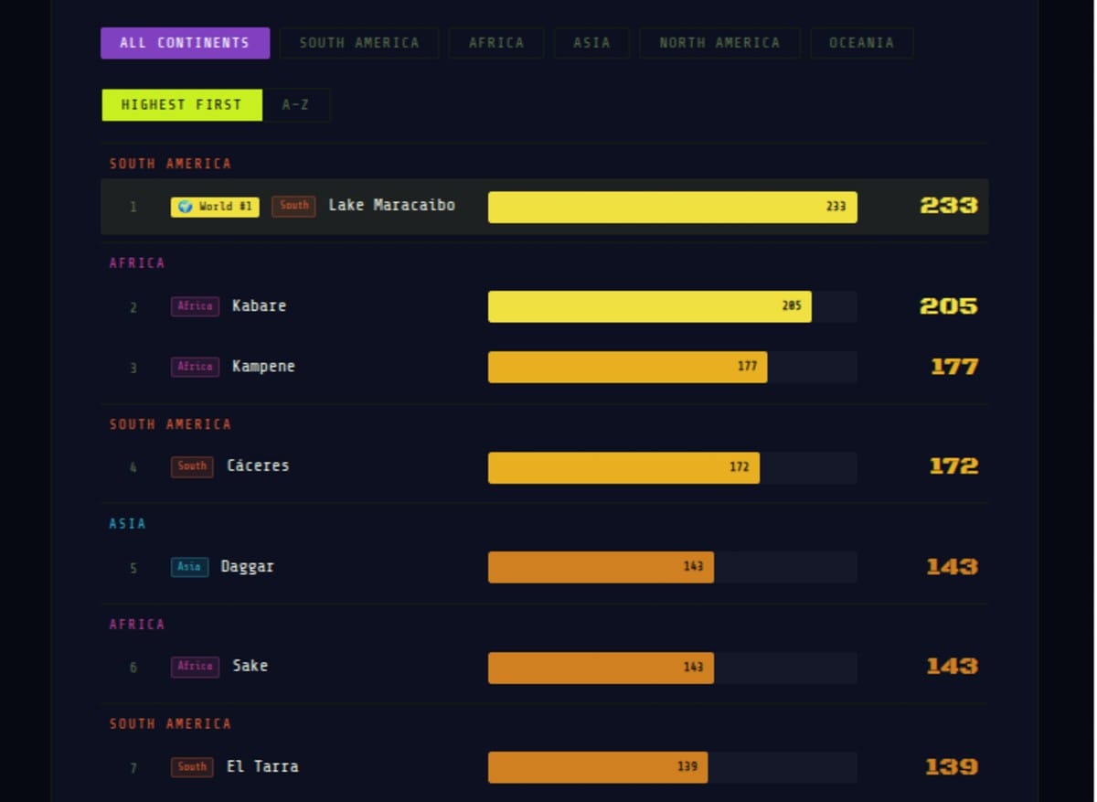
HOTSPOTS Lake Maracaibo in Venezuela records 233 lightning flashes per square kilometre per year — the most electrically active place on Earth. Across Africa's Congo Basin, South Asia, and the tropics, the atmosphere crackles with electricity that shapes climate, agriculture, and human settlement in ways rarely appreciated.
Metric: Flash rate density = flashes per sq km per year · Top 3 hotspots per continent
NASA Lightning Imaging Sensor (LIS) covers ±38° latitude (tropical + subtropical regions only)
Areas north of 38°N — including most of Europe — are not included in the dataset
Sources: NASA · Bulletin of the American Meteorological Society (AMS)
NASA Lightning Imaging Sensor (LIS) covers ±38° latitude (tropical + subtropical regions only)
Areas north of 38°N — including most of Europe — are not included in the dataset
Sources: NASA · Bulletin of the American Meteorological Society (AMS)
⚡ Lake Maracaibo, Venezuela — 233 flashes/km²/year
The most lightning-active location on Earth. A unique geographic funnel where warm Caribbean moisture meets the Andes, producing near-daily electrical storms — known locally as "Catatumbo lightning" — visible for 400 km. Mariners historically used it as a natural lighthouse.
The most lightning-active location on Earth. A unique geographic funnel where warm Caribbean moisture meets the Andes, producing near-daily electrical storms — known locally as "Catatumbo lightning" — visible for 400 km. Mariners historically used it as a natural lighthouse.
Lightning Flash Rate Density · Top Hotspots by Continent
Bars scaled to Maracaibo's 233
Hover for detail
Hover for detail
📡 NASA LIS coverage: The Lightning Imaging Sensor tracks lightning only in tropical and subtropical regions at ±38° latitude. Areas north of 38°N — such as most of Europe, Canada, and Russia — are not captured in this dataset, which explains why only North American, South American, African, Asian (South/Southeast), and Oceanian (Australia) hotspots appear.
Sources: NASA Lightning Imaging Sensor (LIS) · Bulletin of the American Meteorological Society · Flash rate density rounded to nearest whole number
233Lake Maracaibo
World Record
World Record
205Kabare DRC
Africa's Highest
Africa's Highest
143Daggar Pakistan
Asia's Highest
Asia's Highest
121Rajauri India
#2 Asia
#2 Asia
⚡ What Creates a Lightning Hotspot
Lightning requires three ingredients: moisture, atmospheric instability, and a mechanism to lift warm moist air rapidly enough to create the charge separation that produces electrical discharge. The places that record the highest lightning density are, almost without exception, located where geography amplifies all three conditions simultaneously: tropical or subtropical warmth provides moisture and instability, while mountains, valleys, or coastlines provide the lifting mechanism that forces air upward fast enough to generate the electrical conditions for lightning.
The global distribution of lightning is therefore not random — it is a precise map of where tropical moisture interacts with orographic uplift (mountains forcing air upward) or convective instability (warm surfaces heating air from below). The Congo Basin's extraordinary lightning density, the South American Andes-Amazon interface, the foothills of the Himalayas and Karakoram, and the monsoon-driven tropics of South and Southeast Asia all appear in the top rankings for exactly these reasons. Flat, dry, or cold regions have relatively little lightning by comparison. Lightning is essentially the atmosphere's electrical exhaust from the work of moving heat from the tropics toward the poles.
Lake Maracaibo records 233 lightning flashes per square kilometre per year. Mariners have used its near-continuous electrical storms as a natural lighthouse for five centuries. It is one of the most spectacular geophysical phenomena on Earth.
⚡ Lake Maracaibo: The World's Lightning Capital
Lake Maracaibo's 233 flashes per square kilometre per year is the highest flash rate density ever recorded for a geographic area by NASA's Lightning Imaging Sensor. The phenomenon — known locally as "Catatumbo lightning" after the Catatumbo River that flows into the lake — occurs almost nightly for much of the year, producing electrical storms of extraordinary duration and intensity. The storms typically begin in the evening and last into the early morning hours, producing 1,000-40,000 lightning flashes per night visible for distances of up to 400 kilometres.
The mechanism behind Maracaibo's extreme lightning density is well understood. Lake Maracaibo is surrounded on three sides by the Andes and Venezuelan Coastal Range, creating a topographic bowl that channels warm, moisture-laden Caribbean air inland throughout the day. As evening falls and the land cools faster than the lake, a distinctive nocturnal land-lake breeze system develops that concentrates atmospheric moisture over the lake and generates powerful convective cells. The Catatumbo lightning is so consistent and geographically fixed that it served as a natural navigation beacon for Caribbean mariners for centuries — it is referenced in navigation records from the 16th century onward.
⚡ Africa's Congo Basin: The Lightning Continent
Africa dominates global lightning density rankings more broadly than any other continent. The Congo Basin — centred on the Democratic Republic of Congo — records flash rate densities that rank among the highest in the world, with Kabare at 205 flashes/km²/year, Kampene at 177, and Sake at 143. The DRC's dominance of Africa's top lightning spots reflects the extraordinary atmospheric energy of the Congo rainforest, the second-largest tropical rainforest on Earth.
The Congo Basin's lightning is driven by the same thermodynamic mechanisms as Amazonian lightning: the forest itself generates moisture through evapotranspiration (trees release water vapour), which combines with equatorial solar heating to create powerful convective cells. The Congo Basin's position in a relatively enclosed geographic basin, surrounded by higher elevation terrain, further concentrates convective energy. Africa's overall lightning density — the continent receives approximately 1 billion lightning strikes per year — makes it the most electrically active landmass on Earth, with significant consequences for fire frequency, soil nitrogen cycling, and forest ecology.
⚡ South Asia: The Monsoon Lightning Belt
Asia's lightning hotspots are concentrated in South Asia — Pakistan's northwest frontier (Daggar at 143, Doaba at 119) and India's Jammu & Kashmir region (Rajauri at 121) — reflecting the interaction of monsoon moisture with the foothills of the Himalayas and Karakoram mountain ranges. This region, where the Indian subcontinent's summer monsoon moisture meets the steep orography of the Hindu Kush, Karakoram, and Himalayan foothills, creates ideal conditions for intense convective thunderstorms.
The concentration of high lightning density in the Pakistan-India border region is significant for reasons beyond meteorological interest. These areas are among the most densely populated high-elevation zones in the world, where subsistence agriculture in mountain valleys creates significant exposure to lightning strike risk. Lightning-related mortality in South Asia is substantially underreported but is estimated to be in the thousands per year, concentrated in exactly the geographic zones that record the highest flash density. The correlation between lightning hotspot geography and agricultural mortality risk is direct and consequential.
India's Rajauri at 121 flashes/km²/year places it second in Asia and among the top ten globally — a figure that reflects the extraordinary atmospheric energy concentrated in the Pir Panjal Range's interface with the Jhelum Valley monsoon moisture. India's broader lightning geography — with additional hotspots in the northeastern states, the Eastern Ghats foothills, and the Western Ghats — makes it one of the world's highest-lightning-mortality countries, with the Indian Meteorological Department reporting approximately 2,000-2,500 lightning-related deaths per year, the majority occurring in agricultural communities during the monsoon season.
⚡ Lightning and the Global Nitrogen Cycle
Lightning's ecological significance extends far beyond the dramatic electrical display. Each lightning bolt generates temperatures of approximately 30,000 Kelvin — five times the surface temperature of the Sun — in a channel a few centimetres wide. At these temperatures, molecular nitrogen (N₂) and oxygen (O₂) in the atmosphere react to form nitrogen oxides (NOx), which are subsequently converted by atmospheric chemistry and rainfall into nitrates that fertilise soils and oceans. Lightning generates approximately 5 million metric tonnes of fixed nitrogen per year — roughly 10% of all natural nitrogen fixation on Earth, comparable to biological nitrogen fixation by all terrestrial legumes combined.
This means the geographic distribution of lightning density is also a map of natural nitrogen fertilisation: regions with high lightning density receive substantially more atmospheric nitrogen deposition, contributing to the fertility of tropical soils that might otherwise be depleted by intense rainfall leaching. The Congo Basin and Amazon's status as both lightning hotspots and extraordinarily productive ecosystems is not coincidental — the electrical storms are part of the biogeochemical system that sustains the forest's productivity. The same mechanism operates at smaller scale in South Asia's monsoon-driven lightning belt, contributing to the agricultural productivity of the Indo-Gangetic Plain.
End of Brief · Prism ⚡